Today's Canals - Dudley No 2, Dudley No 1
We had a slow start to the day (great weather!) as the basin shop did not start serving until 10 am. this gave us a a chance to do various servicing, including removing more plastic from around the prop.
Christine decided that as well as filling with diesel we should also take a bag of coal and a net of logs just in case the temperature drops suddenly! Overall we have been most impressed by the welcome and service that we received here - recommended to anyone. Thanks Dee!
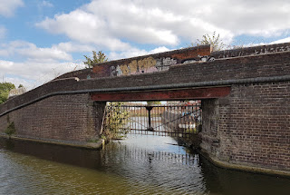
It was 10:30 before we were able to unmoor, turn the boat around and head out through the narrow towpath bridge.
Not all former industrial sites are redeveloped into housing - this one (we think) is Mapei, an Italian multi national manufacture of adhesives and surfacing products for the construction industry.
Before long we were approaching the southern entrance to Gosty Tunnel. Having cleared the prip we had hopes of a quicker passage than yesterday - we certainly crossed wide space before the canal at speed! However, we soon realised that the speed in the tunnel is determined mainly by the bore and the water depth, neither of which allowed us to make much speed at all! We wondered if we might have been quicker of we reverted to the traditional legging technique!#
At least we managed a few photos from inside - this one shows the lowest point in the tunnel. It varies from quite low to almost cavernous.
We also managed the obligatory shot . . . This is the point at which, from the northern end, the roof level changes abruptly. From the other end it is much more gradual.
Just before we arrived back at Windmill End this short arm branches off to the right. We wondered if it led anywhere interesting. On the old maps it simply describes the site as Breeze Oven Perhaps like us you have never heard that term before, Looking it up (and there are very few references to help as the name seems to have been taken over to describe a domestic gadget, quite different) we found that it makes 'small coke'.
We moored just around the corner at the junction for our lunch break.
It was a bit early so Mike took the time to walk up the hill to take a closer look at the remains of Cobbs Steam Pumping Engine House. This was used to remove water from the main mine in the area, a problem that was long one of the biggest challenges for mining - something that drove the development of stationary engines.
On the way up, from a former railway bridge, there was a chance to look back at the southern portal of Netherton Tunnel.
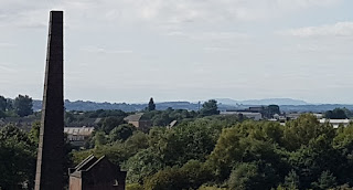
From the top of the hill there was a good view. In the far distance, according to a local dog walker, are the Malvern Hills.
In the afternoon we set off towards Park Head where we planned to go up the three locks to the entrance of the Dudley Tunnel.We recalled from a visit some years ago that there is a good open area where we planned to stay the night.
Soon we passed the Withymoor Island Moorings. Tere are about half of the boats moored on line with the others along what seems to have been a short arm, perhaps even a bypassed loop. In fact, this was the site of a major rail-canal transhipment facility where the canal ran into a large shed so that loading could be done in the dry. There never was a way back onto the main line at the other end.
A little further comes Primrose Basin, accessed under a typical towpath bridge. This was created as yet another transhipment facility.
The original line follows the contour up to Park Head where it turns sharply through almost 180 to go back along the other side of a valley. Later, to save time, a short cut via two locks was constructed (hence the name Two Locks Branch) but was soon disrupted by subsidence from mining woks underneath. Although long abandoned, the splendid turnover bridge at the start is intact.
We started to go much slower and suspected something around the prop so pulled to the side and removed a quantity of plastic and metal threaded material. Fortunately it came away quite readily. We were almost at Blowers Green where we were able to dispose of it at the Boaters Facilities.
Christine walked across to the first of the Park Head locks to prepare it for Mike to bring the boat in. After opening the first paddle she noticed that the around the gates was a piece of wire holding a sign that said Danger. \we were not aware of any closure and people were walking and cycling the towpath. A local person suggested that it was something to do with the Metro Extension project which will cross the disused viaduct that runs over the locks. It was also suggested that some lock gates were being taken out and replaced a short time ago. If this would have caused us a significant delay then we might have investigated further but it seemed sensible just to turn around and return to Windmill End for the night.
After mooring up we both - at different times - walked around the Bumblehole country park, following the line of the old loop. In 1887, the loop was still complete and boats could still go all the way round to rejoin a few hundred metres at the junction with the Netherton Tunnel branch.
By the start of the century maps show that part of the loop was no longer usable - it seems that the mining or quarrying had left a large hole, now filled with water, and undermined the canal.
At the mid point of the loop a further arm used to serve a small mine but now is largely filled in, leaving just a winding hole. A small residential mooring community live here. Christine had a long chat to one of the boaters.
Bumblehole Arm ends rather ignominiously!
A little bit of the lost section can still be followed but the rest is invisible.
The other end, now named Boshboil, is much shorter and seems not to be used although, if there were sufficient depth of water, would be a pleasant mooring.
8.1 Miles - 0 Locks


No comments:
Post a Comment