Today's Canal - Wyrley and Essington
It was a splendid morning as we left our mooring alongside Pelsall Wood, much better than the uniformly grey that had been promised.
 |
On the opposite side had once been a substantial iron works in the 19C but the next bridge not only reminds us why it was built there but also that the works closed a very long time ago.
Lord Hay's Branch ran from this point for just over a mile to a colliery and limekilns at Newtown. By 1920 most of it had been abandoned and shown on maps going as far as another colliery much closer to the main canal. The line can be seen clearly on an aerial view ahjd here as the hedge at the far side of this field. The original terminal basin is now underneath a large care home! It is from this point on the W &E that it is hoped that the restored Hatherton Canal will join in. Despite the fingerpost at Pelsall Junction, the old route via the Cannock Extension is no longer possible and this half of the canal will be a new build with only the half at the Hatherton end following the original route. It will use the last few hundred metres of Lord Hay's Branch.
A large site at Goscote is eventually being re-used for residential housing. Almost a decade ago we noted it was abandoned and three years ago still awaiting work to start.
This was once Elkington's Copper Works which refined copper using an electrolytic process. James Elkington was granted the first patent for such a process which was quickly followed by plants in US. Previously it was refined by fire. As with any new technology, it took several years and many different attempts before it was largely problem-free. It closed in the 1980s. It then took many millions to decontaminate the site.
Willenhall/Bloxwich was used to relocate people displaced from slums elsewhere and in the inter-war period a large quantity of poor quality developments took place followed by more in the late 1940s. By 2000 most of the industry had closed including its famous lock makers. Many parts of the town gained a reputation for crime, poverty and deprivation. Some estates have been renovated and a few have been demolished. Together with former industrial sites there is now a lot of new housing although it does seem to be very high density and many properties seem very small. Some estates appear to be maturing well.
This row of older properties have gardens that run down to the canal. Quite unusually many of them have pigeon lofts, something that we have not seen for a long time.
At Birchills Junction we thought that this large industrial unit with a distinctive ornamental feature must be the headquarters of a large corporation but, no. It is a regional distribution centre for TKMaxx, the country's largest off-price clothing retailer.
You may not be able to see it clearly (we were a little slow in taking the picture) but the only way down to this improvised fishing stand is using the blue looped rope ladder to assist down (and then up!) the retaining wall!
At Sneyd Junction we paused to use the services. Mike also checked out the expandable XHose that he thought had failed when we filled up over a week ago. To his surprise it seemed now to be working - but by then he had already filled up this time so the real test will be at the next fill.
We passed under the noisy (very) M6 bridge and started to look for a lunch time mooring. Ahead we knew was the Rough Wood Country Park where we stopped twice,including once overnight)( some years back. Our reports then recorded that we could not get right to the bank and today was no different but it was very much more peaceful than anywhere nearby.
After lunch there was again a proposal to stay here until tomorrow - we had been thinking about looking at the short arm of the former Bentley Canal in Wednesfield (handy for shops). But we did need to tidy up our mooring to be a bit more secure. It had been tested whilst we ate with a boat going by! We are now up to three moving boats on the northern BCN!
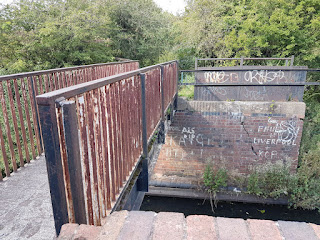
We were close to Bentley Wharf Bridge. This appears on maps for at least 120 years but there is no clear reason why it was built wide and then replaced with a narrow footbridge. There certainly has been no railway or road across in that time.
In the afternoon we took short walks to the country park- it seems to be generally scrub land ith plenty of foot and cycle paths but there may be other features further away.
7.8 Miles - 0 Locks


No comments:
Post a Comment