Monday, 31 July 2017

Stanley Ferry

Today's Navigation - Aire and Calder

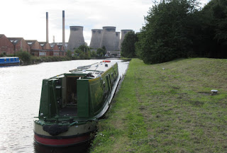
The day began really bright - and, yes, we did manage a better picture of our mooring than last evening!


Mike walked the short distance down to the lock, across the footbridge, with the old lock cottages now used as private residences, to a short row of small shops in Ferrybridge. Although rather more of the shops are now closed than we had seen on StreetView, Mike did manage to get the three items he was aiming to buy.

As it is really a flood lock, we did not have much of a rise but Christine did have to clamber somewhat to get back on the boat afterwards as there is not proper lock landing.


The next stretch is a wide part of the River Aire - strangely wider than the part we did yesterday which is further downstream. We passed under first the modern concrete road bridge and then the older stone bridge that previously carried the Great North Road.


We gradually came around the huge Ferrybridge Power Station site - although the huge cooling towers still dominate the skyline they no longer fulfil their proper role as the station is now closed as part of the move away from coal generation of electricity. At one time the River Aire was busy with barges carrying coal from the various nearby mines. A unique system, called Tome Pudding Boats, was one of the methods used. A string of up to twenty almost square tubs were linked together in a chain with just a single pusher tug. (A few remaining examples can be seen at the museum in Goole which we visited five years ago). When the boats arrived at the power station they were unloaded by this huge mechanism which picked up a boat, turned it over and emptied all of the contents onto the awaiting conveyor system. In the 1960's we did actually pass one string of Tom Puddings but it is a long time since they operated.


Nature has rapidly reclaimed much of the river bank and most of it is now very pleasantly green.


Just occasionally a pit waste heap can be seen, with nature taking a little longer to cover it.


Some people know how to make a real bijou picnic site!


A couple of former colliery loading basin can just be spotted with a narrow access onto the river.


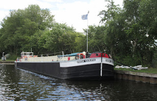
Eventually we arrived at Bulholme Lock. Above the lock is moored Freda Carless, an historic boat that is being preserved by National Historic Ships UK. It was built in 1964 in Knottingley and finally ceased service in 2005. It carried around 360 tones of cargo, generally sand.


At Castleford we called at the service point for a full range. Christine had done two loads of washing as we cruised along this morning so filling the water tank took quite a while. Mike attempted to find out from CaRT customer services when Woodnook Lock would be open. Last night we received by email a stoppage notice that a stalk was broken - we later found out that this means the bar that is used to pull up the top gate sluice paddles. However the person answering was no more informed than we already were.


So we set off through the flood lock - this time the gates were open at both ends.


Out then onto the wide open cross roads where right is to Leeds, left to a large weir (so not navigable) and ahead to Wakefield which is where we were planning to go. Since we really did not want to go to Leeds, we opted to press on to Woodnook and hope to find out more when we got there.


We moored below the lock and just caught a couple of the people who had been investigating - unsuccessfully - the problem. All that they knew was that somewhere underground the stalk is catching on something and becoming stuck. However, one of them thought that the lock could still be operated manually and that a lock keeper was being arranged for a short perios this afternoon. He suggested we try again to contact Customer Services. This time we had a more helpful person who took time find out more information. When she came back the the answer much more encouraging - we should be able to pass through between 2.30 and 3.30 this afternoon. Since it was now just after 1.30, and lunch was still not complete, this was cheering news.

A short while later a large CaRT work boat came upstream and tied onto the lock landing. It was due to pick up some new balance beams from the Stanley Ferry workshop and had been told that he would be penned through at 2 o'clock! In addition, the next two locks were being manned to see him through and we could tag along behind!


The lock was already empty so when the lock keeper arrived he could open the gates and let us both in. (everything apart from the top sluices was working mechanised) However, the manual gate paddles had obviously not had a lot of use and a further team of three was needed to persuade them to open.


They must have been over-enthusiastic and they over-wound one paddle such that it came adrift inside the winding gear! Some dismantling and heavy engineering (ie a heavy hammer and a wrecking bar!) were deployed. The gate paddles are nt a speedy way to fill the lock and it was almost 45 minutes before the top gates could be opened and we were both on out way again.


As promised another member of staff, travelling by van, had the next two locks ready and waiting and closed up after we had left.


At Stanley Ferry workshop the work boat tied up alongside several large piles of gates and timbers being continuously watered. This is to condition the wood before the gates are then immersed in the canal for the next 25 years or so.


Immediately after the aqueduct we came alongside with some difficulty in  order to fill up our fuel tank. Boats were moored in the way and the wind was quite strong and insisted that we really ought to be on the other side of the canal. Eventually, Christine manged to jump off only to discover that the boatyard is closed today - open in in the morning! Just as well we were not down to our last few drops.

We continued on down the straight cut to Broadreach from where it was not far to Wakefield where we we planned to moor tonight. However, half way along we suddenly saw a wave from one of the moored boats - it was Mark from nb Ellis - he has followed our build blog and we have followed his. (You should see a link to his latest entry in our Blog List column on the right)We just had to stop to chat - easier said than done since we were already just passed and the wind was again less than helpful - this time blowing in quite the opposite direction (both wrong at the time!) Of course, we had to show off our respective boats with guided tours and detailed examination of which features work or not!


This took some time before we set off once more - Mike was too busy with steering the boat away from the moorings and only managed a photo as we left Ellis behind! By now it was rather late to press on to our planned overnight stop so we pulled in at the end of the visitor moorings just before Broadreach Lock. It is, however, good to put a reality to a fellow blogger!

11.8 Miles - 7 Locks

Sunday, 30 July 2017

Ferrybridge

Today's Navigations - Selby Canal, River Aire, Aire and Calder Canal

We had a gentle start to the day and we planned to go to Selby Abbey for their morning service at 10am. Leaving Alice, who opted for a long read on the boat, we walked into town. At the Abbey we received a warm welcome. Normally they have a strong, highly trained, formal choir but it was a holiday week off for them so we had to manage without their help! There were around 100 people and it was well conducted with a carefully prepared sermon from the vicar. The Abbey itself is a very impressive building and it is interesting to see how they manage to make it feel appropriate for the much smaller numbers than the whole place can accommodate.


We did not spend much time after the service - we could have stayed for coffee and biscuits - as we wanted to return to the boat at the time we promised Alice we would. As we walked back we noticed that the flood under the railway bridge had cleared, despite some heavy overnight rain.


Although this impressive terrace is shown on the older OS maps, there is no label to indicate its origins. The main part in the middle now houses an Exotic Kashmiri Cuisine Restaurant, but what else has it seen? A Selby Council web page indicates that it was once a Salvation Army Hall - we heard this morning at the Abbey that they are still strong in the town. Mike and Alice saw their new place when they walked to the shop on the evening after Alice arrived.

We quickly changed and moved the boat to the service point as, with the extra showers, the water tank was already down to half full (or half empty depending on your point of view!)


Christine and Alice walked to the swing bridge to prepare it for Mike who first had to turn the boat around. In the dense weed this was rather slow! They started to operate the bridge open procedure which begins with flashing warning lights followed by red ones before the barriers start to come down. Despite all this a car jumped the lights and sped across, fortunately in safety. However, a white van followed and was tempted but alas as he was under the first barrier he spotted the other one closed and hesitated with the result that the barrier came down onto the van roof!


Luckily the barrier did not seem to be damaged - we had visions of being trapped in the basin for another day whilst it was mended! On a Sunday this would have taken at least until the next day probably with a lot of irate drivers - this bridge does seem to be a bit of a 'rat run' off the estate on the other side.


To clear the bridge, Christine had to start the open barriers sequence and go right through to the end, even having to remove the key before it would restart. Eventually we were on our way.


It was a pleasant morning as we cruised down the five miles or so of the Selby Canal. We think that this building is the site of what was originally a licorice factory but we have not yet found out very much about that operation. Later, the location became a chemical works which can be seen behind this building.

The efforts of the weed collecting boat seem to have been worth it as, apart from the basin itself, there was much less coverage of the water thereafter.


May be it was just the sunshine, but it did feel as if the lilies in the margins had come out since we arrived, both the white cultivated? type as well as the common yellow ones. Oh, and what is that blue type - just as well the photo is blurred!


Some of the banks still had splashes of colour.

A short light shower intruded so when we arrived at Haddlesey we paused on the visitor mooring just before the flood lock to finish lunch.


It was back to fine weather as we then emerged onto the River Aire - the strong stream marker was well into the green and the flow was much as we would normally have expected. Each river reacts to rain differently.

We could see two very heavy showers in the distance either side of us but, our luck was in, and they both passed us by and we remained in the brighter weather in between.


The river section was very pleasant - the water ski club were in operation. When we passed them they seemed more intent on seeing who could push thew other off the pontoon! A little later Mike jumped at least three feet into the air as their speedboat (which he had not spotted coming up behind) did a 180 degree turn on the spot, right on our tail!


We passed through Beal Lock - again only a very small change of level - and then on to Bank Dole. here a boat was already in the lock ahead of us but had not started to fill as we came onto the lock landing pontoon. However, they did not spot us and continued ascending - very slowly! Still, we did not have an urgent timetable to meet. Our only concern was to find a reasonable mooring for the night - not always so obvious along this navigation as much of it is river. A boater who was moored on the visitor mooring at the junction warned us that they were full - but at least he offered to close the lock for us.


We continued for a short distance, passing the huge flour mill,  until the Ferrybridge flood lock was in sight - together with the huge cooling towers. There are supposed to be visitor moorings here but our memory was that they were not brilliant.


So, just a short way before we found a pleasant stretch by the towpath and pulled in for the night. (The sun was in thew wrong direction for a better picture. Perhaps we can try again in the morning) The large commercial boats have long since ceased to come this way so we felt a little easier on the mooring. Time then to put the roast lamb dinner on to cook!

13.8 Miles - 3 Locks

Saturday, 29 July 2017

York, Jorvik and a Golden Day

To make up for not having been able to cruise up to York we opted for another train journey. We had booked Fast Track tickets for the Jorvik Viking Experience, a new exhibition that has just opened, replacing the one that was destroyed in the floods a couple of years ago. It is not possible to buy these tickets on the door - only people queuing on the day can do that - so we had booked them online. We had also booked a table for lunch at Cote, a Brasserie that Mike had been to a few weeks back when in York for General Synod.


As we walked to Selby station we could see that the heavy overnight rain had left its mark with even deeper flooding under the rail bridge than last night, so much that that part of the bridge underpass was closed.


The trains were busy but still enough seats for all and it was again a very efficient journey to York. We had well over an hour before our lunch date so we walked to Micklegate where we left the walls yesterday evening and continued around in an anti-clockwise direction.


The image is carved in one of the flat stones of the walkway - is it a game or just a pattern?


The wall walk comes to an abrupt break just before Skeldergate Bridge. It was once almost continuous but 19th century developers had no scruples about demolishing anything that was in their way and when they decided that a new bridge was needed. One of the information boards reported that this action so incensed the then Archbishop of York that he made a fuss and the walls were then given a special protected status. Not sure whether this was before or after the railway companies had their go but they at least only made arches through the wall.


Across the other side of the bridge and Christine spotted this board recording various flood levels. We think that it has not been updated to show the most recent floods in 2012 and 2016.


Next, we passed Clifford's Tower, an ancient Motte and Bailey - in this form it dates back to Henry III bur replaced an earlier wooden castle built by William the Conqueror. We did not really have time to climb up to the top - certainly not to do justice to the entrance charge!


Wandering through the streets of the city centre we came to All Saints Pavement Church with its distinctive lantern style tower. It dates back to medieval times and became the regimental church for the Royal Dragoon Guards - one window is a memorial to them.


A modern window, installed about five years ago and funded by a local appeal, is in memory of those who served in Afghanistan, especially those who died in combat.


A street market has an enormous variety of mostly food outlets with the stall holders vying to take money from visitors by many new or unusual ways.

By now it really was time for lunch and we headed to Cote where a table was awaiting us. We had a really excellent meal - nibbles of sourdough, garlic bread (really impressive) and olives whetted out appetites for the main courses. Alice opted for Salmon Fishcakes, Christine a duck confit and Mikea veal escalope.


We did still have room for a dessert and Alice took Mike's advice (from recent experience) to have the Creme Caramel au Citron whilst Christine selected a chocolate mousse.


When that was done and dusted, there was time to come around in front of the Minster but as we were too close to take a decent photo, this one of a model gives a good idea of the position of the building in relation to the narrow streets around.


A nearby house was Guy Fawkes's birthplace - wonder what happened to him?

Now we headed to Jorvik where we smugly took our place in the very short Fast Track queue, pleased that we did not have to wait in the much longer line for day tickets.

After a small display about the excavations in the 20C of the Viking remains on the site when redevelopment  took place following the closure of the Craven's Confectionery factory, we came to the main part, a 'train' ride through a detailed reconstruction of life in those ancient times. Each carriage was suspended from an elevated track and played a commentary into each passenger' ears in a language of choice.


We were told that we could take photos - which we did - but not to use a flash. As a result almost all of them are too fuzzy to use and this is the least worst! Each display has animatronic figures - although one had two real humans just to confuse everyone!

After the train ride there was a display room which looked at Viking times in some depth, based on the archaeology of this area. There was a series of talks - the one we listened to explained how two apparently similar bone fragments had come from different animals and probably for very different purposes. We were there for about an hour and a half and came away thinking that we now knew a lot more about life in York around the time of the Vikings.


We walked back to the station over Ouse Bridge and could see that the river level had risen still further - comparing this photo with one taken yesterday there is at least one rung of the ladder more under the water.

So why 'a golden day' as in the title? Fifty years ago to this day, in Keele University Chapel two people were married - and have remained so.