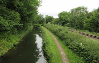
Our overnight mooring was just a short distance from the entrance to the former Norwood Tunnel.
At this point the railway line runs very close to the canal and at the same level. Just a little further, the line has climbed to well above the canal and eventually crosses the summit well above the tunnel. The canal is rather narrow in places.
We cruised up to the last winding point, opposite the large feeder cascade that keeps the canal topped up from the summit. There are other feeders lower down.
We had thought about walking across the whole length of the tunnel to see what there is visible at the other end but decided against this and strolled up to the tunnel entrance. The portal looks much higher above the level of the canal that we expected but we have found an older photo that shows that the tunnel profile, at least at the entrance, is much taller than is often the case.
At the gateway into the fields we were tempted to walk a bit further. We had been thinking that we had not seen or heard any trains on the when one arrived. Just as we were poised to photograph it, it stopped (in fact just outside the previous station) inconveniently mostly behind trees! A little later it returned in the direction from which it had come.
We were surprised to see quite a bit of water in a depression in the ground above the tunnel but of course this was once a large coal mine and so it may well have been formed by the same subsidence that caused the tunnel inside to collapse and thereafter by closed for navigation.
A little further on and, after crossing the road, we saw a CaRT sign announcing the entrance to Kiveton Water which turned out to be an angling lake, obviously rather popular going by the cars in the special fishermen's car park.
Alongside was a sign telling us that we were now in a Community Woodland and information boards further on revealed that this whole area was once Kiveton Colliery which closed in 1994 but it was only in 2005 that the land was rescued from dereliction and decay. Now it is an extensive country park, a great facility for local residents or even those from further afield. The large waste tip has been much reduced and contoured into a smooth mound.
The only remains of the colliery that we could see is the Victorian Old Colliery Offices (built in 1869 as the village school) which have been converted to some other uses.
There were alongside at one time the colliery baths and a very interesting board gave the history of how pithead baths were introduced - as with so many social developments it took an inquiry and legislation to eradicate the practice of miners returning home in filthy work clothes, washing in a tin bath in their miner's cottage front room. These baths were opened in 1938. Although this building was Grade II Listed it became so vandalised that it had to be demolished just a few years ago.
At this point we turned around and re-traced out steps back to the tunnel entrance. As we then walked on the towpath we could see quite a lot of fish in the canal, some reasonably large ones - surprisingly no anglers here (perhaps that's why the fish can grow to this size!)
Close to the tunnel alongside Kiveton Park station a couple of ruined buildings can be seen at the edge of the canal towpath. The guidebooks and information board state that these were party of facilities to load stone from the adjacent quarries on to canal boats to be taken much further afield. The most famous use was for the re-building of the House of Parliament.
A little further along the summit we spotted this boundary stone. With little to go on from our guidebooks we had to wait until later to find out more about it- but so far nothing has emerged. Anyone know what it is?
Time then to begin our descent back down the long flight of locks. The start is a treble staircase. With the need to set up the locks first and then having the limiters on the intermediate gates, the staircases, especially the two trebles, take a remarkably long time to pass through.
The grey clouds which had arrived earlier in the morning gave way to blue skies shortly after entering the locks.
We had lunch on a lock landing mid flight and then another break at Turnerwood Basin to enjoy the ice creams that we bought here yesterday.
The lock immediately below the basin is called Quarry Lock. Although we could see no evidence of quarrying here in the recent past, a large modern house alongside the lock seems to be that of the owner of a large specialist stone supplier, Cowley Stone. Google shows extensive storage in behind.#
The last lock in the flight arrived as a welcome sight with only Boundary Lock still to tackle before we planned to find a mooring. Whilst Mike tied up, Christine went to the nearby village shop for a newspaper - alas this late in the day they were sold out.
4.9 Miles - 23 Locks


No comments:
Post a Comment